SERVICES
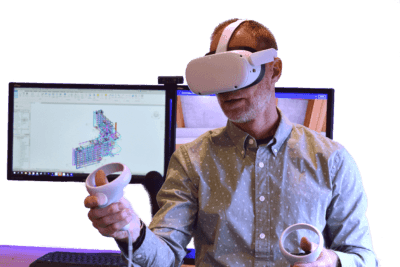
See Your Jobsite In 360° View, and control project progress with 360° photos, enabling teams to stay on schedule and on budget. Digital twins reimagined, reenginered, and ready for anything...
See Your Jobsite In 360° View, and control project progress with 360° photos, enabling teams to stay on schedule and on budget. Digital twins reimagined, reenginered, and ready for anything...
See Your Jobsite In 360° View, and control project progress with 360° photos, enabling teams to stay on schedule and on budget. Digital twins reimagined, reenginered, and ready for anything...
See Your Jobsite In 360° View, and control project progress with 360° photos, enabling teams to stay on schedule and on budget. Digital twins reimagined, reenginered, and ready for anything...
See Your Jobsite In 360° View, and control project progress with 360° photos, enabling teams to stay on schedule and on budget. Digital twins reimagined, reenginered, and ready for anything...
See Your Jobsite In 360° View, and control project progress with 360° photos, enabling teams to stay on schedule and on budget. Digital twins reimagined, reenginered, and ready for anything...
See Your Jobsite In 360° View, and control project progress with 360° photos, enabling teams to stay on schedule and on budget. Digital twins reimagined, reenginered, and ready for anything...
See Your Jobsite In 360° View, and control project progress with 360° photos, enabling teams to stay on schedule and on budget. Digital twins reimagined, reenginered, and ready for anything...
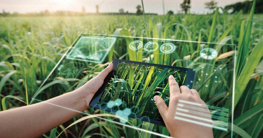
An innovative farm management dashboard that integrates data from our five drone-based agricultural services. Our dashboard provides farmers with real-time updates on crop health, yield estimates, pest infestations, and livestock monitoring, giving them valuable insights into the status of their farm. By combining these services, farmers can make informed decisions about resource allocation, crop inputs, and livestock management practices, resulting in increased yields and lower costs. Our dashboard is user-friendly and customizable, allowing farmers to set alerts for specific parameters such as temperature, humidity, and soil moisture. This feature ensures that farmers are immediately alerted when critical thresholds are reached, reducing the risk of crop loss or animal mortality. Our data analytics services provide government agencies with a comprehensive analysis of the farm's performance before and after implementing our drone-based agricultural services. By tracking key metrics such as crop yields, pest infestations, and livestock mortality rates, we can demonstrate the effectiveness of our services in improving farm productivity and sustainability. Our data analytics services provide valuable insights into the agriculture sector, allowing policymakers to make informed decisions about resource allocation and supporting sustainable agriculture practices. Overall, our farm management dashboard and data analytics services provide farmers and government agencies with valuable insights into the status of the farm, allowing them to make informed decisions about resource allocation and support sustainable agriculture practices...
An innovative farm management dashboard that integrates data from our five drone-based agricultural services. Our dashboard provides farmers with real-time updates on crop health, yield estimates, pest infestations, and livestock monitoring, giving them valuable insights into the status of their farm. By combining these services, farmers can make informed decisions about resource allocation, crop inputs, and livestock management practices, resulting in increased yields and lower costs. Our dashboard is user-friendly and customizable, allowing farmers to set alerts for specific parameters such as temperature, humidity, and soil moisture. This feature ensures that farmers are immediately alerted when critical thresholds are reached, reducing the risk of crop loss or animal mortality. Our data analytics services provide government agencies with a comprehensive analysis of the farm's performance before and after implementing our drone-based agricultural services. By tracking key metrics such as crop yields, pest infestations, and livestock mortality rates, we can demonstrate the effectiveness of our services in improving farm productivity and sustainability. Our data analytics services provide valuable insights into the agriculture sector, allowing policymakers to make informed decisions about resource allocation and supporting sustainable agriculture practices. Overall, our farm management dashboard and data analytics services provide farmers and government agencies with valuable insights into the status of the farm, allowing them to make informed decisions about resource allocation and support sustainable agriculture practices...
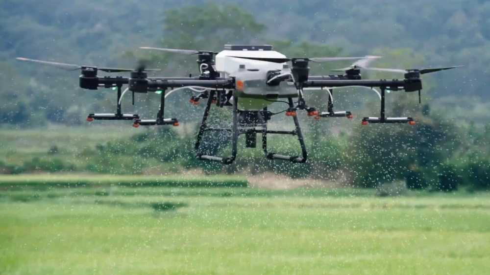
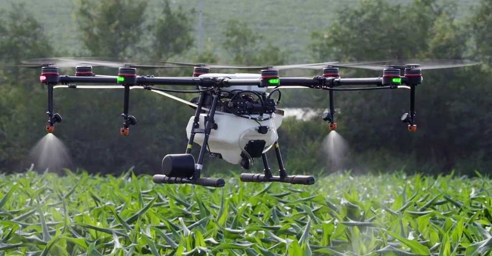
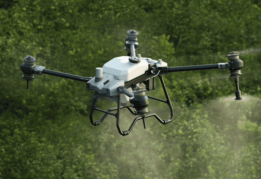
Our specialized drones provide precision agriculture services, such as targeted spraying, seeding, and fertilizing. Using our drone technology, farmers can reduce waste and save money by providing a more efficient, accurate, and environmentally friendly approach to spraying, seeding, and fertilizing in agriculture. Our precision agriculture services are a cost-effective and sustainable way to optimize crop inputs, resulting in increased yields and lower costs.lerisque. Traditional methods of spraying, seeding, and fertilizing in agriculture can be time-consuming and labor-intensive. Our company offers specialized drones for these tasks, providing a more efficient and accurate approach to crop management. Our drones use precision technology to ensure that the right amount of fertilizer, pesticide, or seed is applied to each plant, reducing waste and saving farmers money. With our specialized drones, farmers can cover more acres in less time, allowing them to focus on other important tasks. Moreover, our drones can access areas that are difficult or impossible for traditional farming equipment to reach, such as steep slopes or dense vegetation. This capability improves the overall productivity and efficiency of the farming operation, as more acres can be treated in a shorter amount of time. Our specialized drones also offer environmental benefits by reducing the amount of chemicals used in agriculture. By precisely applying the necessary amount of fertilizers and pesticides, our drones minimize the use of chemicals, resulting in less harm to the environment and the surrounding ecosystem. In addition to these benefits, our specialized drones provide farmers with real-time data on the health and condition of their crops. This information can be used to make informed decisions on future crop management and overall farm planning. In conclusion, our specialized drones offer a more efficient, accurate, and environmentally friendly approach to spraying, seeding, and fertilizing in agriculture. By using precision technology and accessing hard-to-reach areas, our drones can help farmers save time and money while improving the overall health and productivity of their crops...
Our specialized drones provide precision agriculture services, such as targeted spraying, seeding, and fertilizing. Using our drone technology, farmers can reduce waste and save money by providing a more efficient, accurate, and environmentally friendly approach to spraying, seeding, and fertilizing in agriculture. Our precision agriculture services are a cost-effective and sustainable way to optimize crop inputs, resulting in increased yields and lower costs.lerisque. Traditional methods of spraying, seeding, and fertilizing in agriculture can be time-consuming and labor-intensive. Our company offers specialized drones for these tasks, providing a more efficient and accurate approach to crop management. Our drones use precision technology to ensure that the right amount of fertilizer, pesticide, or seed is applied to each plant, reducing waste and saving farmers money. With our specialized drones, farmers can cover more acres in less time, allowing them to focus on other important tasks. Moreover, our drones can access areas that are difficult or impossible for traditional farming equipment to reach, such as steep slopes or dense vegetation. This capability improves the overall productivity and efficiency of the farming operation, as more acres can be treated in a shorter amount of time. Our specialized drones also offer environmental benefits by reducing the amount of chemicals used in agriculture. By precisely applying the necessary amount of fertilizers and pesticides, our drones minimize the use of chemicals, resulting in less harm to the environment and the surrounding ecosystem. In addition to these benefits, our specialized drones provide farmers with real-time data on the health and condition of their crops. This information can be used to make informed decisions on future crop management and overall farm planning. In conclusion, our specialized drones offer a more efficient, accurate, and environmentally friendly approach to spraying, seeding, and fertilizing in agriculture. By using precision technology and accessing hard-to-reach areas, our drones can help farmers save time and money while improving the overall health and productivity of their crops...
Using drone technology, our company offers crop mapping services for the agriculture sector. Our drones are equipped with high-resolution cameras that can create detailed maps of crop fields, identifying areas of potential yield loss or crop stress. This information can be used to optimize crop inputs, such as fertilizer and water, resulting in increased yields and lower costs. Our crop mapping services are an efficient and cost-effective way to improve crop health and productivity. Introducing drone technology in agriculture has the potential to revolutionize the industry and significantly improve crop yields, quality, and overall sustainability. Our company offers drone-based agriculture quality and health scanning services that use state-of-the-art sensors and cameras to collect data on soil and crop conditions. We then use this data to program larger spraying, seeding, and fertilizing drones for more efficient and accurate results. Our drone technology offers several benefits to farmers and the agriculture industry as a whole. Firstly, by collecting data on soil and crop conditions, we can identify areas that require more attention and provide farmers with targeted solutions to improve crop health and productivity. This information can also help farmers make informed decisions on the use of fertilizers and pesticides, leading to a more sustainable and environmentally friendly approach to farming. Secondly, by using larger drones for spraying, seeding, and fertilizing, we can significantly reduce labor costs and increase efficiency. Our drones use precision technology to ensure that the right amount of fertilizer or pesticide is applied to each plant, reducing waste and saving farmers money. Finally, our drone-based agriculture quality and health scanning services can help farmers meet increasingly strict regulations and requirements for food safety and quality. By providing accurate and reliable data on crop conditions, we can help farmers improve their yield and produce higher-quality crops that meet industry standards. In conclusion, our drone-based agriculture quality and health scanning services offer a range of benefits to farmers and the agriculture industry as a whole. We provide accurate and reliable data on soil and crop conditions, leading to more targeted solutions and a more sustainable approach to farming. By using precision technology and larger drones, we can increase efficiency and reduce labor costs while ensuring that farmers meet strict regulations and produce high-quality crops...
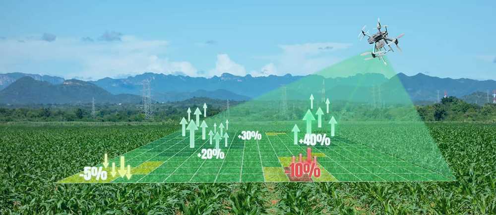
Using drone technology, our company offers crop mapping services for the agriculture sector. Our drones are equipped with high-resolution cameras that can create detailed maps of crop fields, identifying areas of potential yield loss or crop stress. This information can be used to optimize crop inputs, such as fertilizer and water, resulting in increased yields and lower costs. Our crop mapping services are an efficient and cost-effective way to improve crop health and productivity. Introducing drone technology in agriculture has the potential to revolutionize the industry and significantly improve crop yields, quality, and overall sustainability. Our company offers drone-based agriculture quality and health scanning services that use state-of-the-art sensors and cameras to collect data on soil and crop conditions. We then use this data to program larger spraying, seeding, and fertilizing drones for more efficient and accurate results. Our drone technology offers several benefits to farmers and the agriculture industry as a whole. Firstly, by collecting data on soil and crop conditions, we can identify areas that require more attention and provide farmers with targeted solutions to improve crop health and productivity. This information can also help farmers make informed decisions on the use of fertilizers and pesticides, leading to a more sustainable and environmentally friendly approach to farming. Secondly, by using larger drones for spraying, seeding, and fertilizing, we can significantly reduce labor costs and increase efficiency. Our drones use precision technology to ensure that the right amount of fertilizer or pesticide is applied to each plant, reducing waste and saving farmers money. Finally, our drone-based agriculture quality and health scanning services can help farmers meet increasingly strict regulations and requirements for food safety and quality. By providing accurate and reliable data on crop conditions, we can help farmers improve their yield and produce higher-quality crops that meet industry standards. In conclusion, our drone-based agriculture quality and health scanning services offer a range of benefits to farmers and the agriculture industry as a whole. We provide accurate and reliable data on soil and crop conditions, leading to more targeted solutions and a more sustainable approach to farming. By using precision technology and larger drones, we can increase efficiency and reduce labor costs while ensuring that farmers meet strict regulations and produce high-quality crops...
Our drone technology provides crop scouting services for the agriculture sector. We can identify areas of crop fields that require attention, such as areas with lower plant counts or pest infestations. This information can be used to provide targeted solutions to improve crop health and productivity, resulting in increased yields and lower costs. Our crop scouting services offer a more efficient, accurate, and cost-effective approach to crop management...
Our drone technology provides crop scouting services for the agriculture sector. We can identify areas of crop fields that require attention, such as areas with lower plant counts or pest infestations. This information can be used to provide targeted solutions to improve crop health and productivity, resulting in increased yields and lower costs. Our crop scouting services offer a more efficient, accurate, and cost-effective approach to crop management...
Data in Minutes Stand counting using drone technology, providing an accurate and efficient way to assess crop health and determine potential yields. Our drones use high-resolution cameras and advanced image processing algorithms to count plant stands accurately. Using our stand counting technology, farmers can identify the areas of their fields that require attention and provide targeted solutions to improve crop health and productivity. This information is crucial for farmers to make informed decisions on pricing, harvest, and overall farm planning. Counting plant stands is an essential task in assessing crop health and determining the potential yield. However, traditional stand counting methods can be labor-intensive, time-consuming, and often result in inaccurate estimates. Our company offers stand counting using drone technology, providing a more efficient, accurate, and cost-effective approach to crop management. Our drones use high-resolution cameras and advanced image processing algorithms to count plant stands accurately. Our drone technology allows farmers to cover large areas of crops in a short amount of time, providing real-time data on crop conditions, allowing farmers to make informed decisions on crop management. Using our drone technology, farmers can identify the areas of their fields that require attention, such as areas with lower plant counts, and provide targeted solutions to improve crop health and productivity. This information can be used to optimize crop inputs, such as fertilizer and water, resulting in increased yields and lower costs. Moreover, our stand counting technology allows farmers to monitor crop growth and development over time, providing valuable information for accurate predictions of crop yields. This information is crucial for farmers to make informed decisions on pricing, harvest, and overall farm planning. Our drone-based stand counting technology is also environmentally friendly, as it reduces the use of fuel and chemicals and eliminates the risk of damage to crops. Our drones minimize the need for physical labor, making stand counting more cost-effective and accessible to farmers. In conclusion, our stand counting technology using drone technology offers a more efficient, accurate, and cost-effective approach to assessing crop health and determining potential yields. By using high-resolution cameras and advanced image processing algorithms, our drones can provide real-time data on crop conditions, allowing farmers to make informed decisions on crop management and overall farm planning, resulting in increased yields, lower costs, and a more sustainable farming operation. ...
Data in Minutes Stand counting using drone technology, providing an accurate and efficient way to assess crop health and determine potential yields. Our drones use high-resolution cameras and advanced image processing algorithms to count plant stands accurately. Using our stand counting technology, farmers can identify the areas of their fields that require attention and provide targeted solutions to improve crop health and productivity. This information is crucial for farmers to make informed decisions on pricing, harvest, and overall farm planning. Counting plant stands is an essential task in assessing crop health and determining the potential yield. However, traditional stand counting methods can be labor-intensive, time-consuming, and often result in inaccurate estimates. Our company offers stand counting using drone technology, providing a more efficient, accurate, and cost-effective approach to crop management. Our drones use high-resolution cameras and advanced image processing algorithms to count plant stands accurately. Our drone technology allows farmers to cover large areas of crops in a short amount of time, providing real-time data on crop conditions, allowing farmers to make informed decisions on crop management. Using our drone technology, farmers can identify the areas of their fields that require attention, such as areas with lower plant counts, and provide targeted solutions to improve crop health and productivity. This information can be used to optimize crop inputs, such as fertilizer and water, resulting in increased yields and lower costs. Moreover, our stand counting technology allows farmers to monitor crop growth and development over time, providing valuable information for accurate predictions of crop yields. This information is crucial for farmers to make informed decisions on pricing, harvest, and overall farm planning. Our drone-based stand counting technology is also environmentally friendly, as it reduces the use of fuel and chemicals and eliminates the risk of damage to crops. Our drones minimize the need for physical labor, making stand counting more cost-effective and accessible to farmers. In conclusion, our stand counting technology using drone technology offers a more efficient, accurate, and cost-effective approach to assessing crop health and determining potential yields. By using high-resolution cameras and advanced image processing algorithms, our drones can provide real-time data on crop conditions, allowing farmers to make informed decisions on crop management and overall farm planning, resulting in increased yields, lower costs, and a more sustainable farming operation...
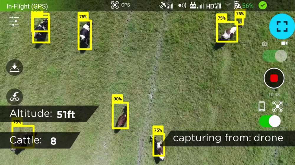
Advanced cattle monitoring services and software to prevent road accidents caused by livestock wandering onto roads in Botswana. Our services utilize a combination of GPS tracking ear tags and drone technology to monitor and track the movement of livestock in real-time. The GPS tracking ear tags allow farmers and herders to set up virtual boundaries and alerts when their livestock stray beyond their grazing areas. When an animal moves outside the specified area, an alert is triggered and sent to the farmer's mobile phone or computer. This provides farmers and herders with real-time information about the location of their livestock, allowing them to respond quickly and effectively to any potential hazards. Our drone technology is equipped with high-resolution cameras and thermal sensors that can detect and track the movement of livestock in real-time. This allows farmers and herders to monitor their herds more efficiently and effectively, and respond quickly to any potential hazards. By using GPS tracking ear tags and drone technology, farmers and herders can prevent livestock from wandering onto roads, reducing the risk of road accidents caused by hitting a cow. The technology also helps to minimize the loss of livestock due to theft and predation by predators. Our cattle monitoring services and software are highly customizable and can be tailored to meet the specific needs of each farmer r herder. We provide comprehensive training and support to ensure that our clients can fully utilize the technology to its fullest potential. Overall, our cattle monitoring services and software provide a cost-effective solution to reduce road accidents caused by livestock wandering onto roads in Botswana. By utilizing our technology, farmers and herders can improve their herd management practices, reduce the risk of livestock loss, and enhance the safety of road users...
Advanced cattle monitoring services and software to prevent road accidents caused by livestock wandering onto roads in Botswana. Our services utilize a combination of GPS tracking ear tags and drone technology to monitor and track the movement of livestock in real-time. The GPS tracking ear tags allow farmers and herders to set up virtual boundaries and alerts when their livestock stray beyond their grazing areas. When an animal moves outside the specified area, an alert is triggered and sent to the farmer's mobile phone or computer. This provides farmers and herders with real-time information about the location of their livestock, allowing them to respond quickly and effectively to any potential hazards. Our drone technology is equipped with high-resolution cameras and thermal sensors that can detect and track the movement of livestock in real-time. This allows farmers and herders to monitor their herds more efficiently and effectively, and respond quickly to any potential hazards. By using GPS tracking ear tags and drone technology, farmers and herders can prevent livestock from wandering onto roads, reducing the risk of road accidents caused by hitting a cow. The technology also helps to minimize the loss of livestock due to theft and predation by predators. Our cattle monitoring services and software are highly customizable and can be tailored to meet the specific needs of each farmer or herder. We provide comprehensive training and support to ensure that our clients can fully utilize the technology to its fullest potential. Overall, our cattle monitoring services and software provide a cost-effective solution to reduce road accidents caused by livestock wandering onto roads in Botswana. By utilizing our technology, farmers and herders can improve their herd management practices, reduce the risk of livestock loss, and enhance the safety of road users...